Latest News
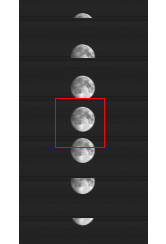
On August 5, 2017, the Terra spacecraft completed a deep space pitch maneuver. During this maneuver, the moon was visible through the MODIS earth-view port. Details are included below. MODIS was in Day Collection rate during the maneuver, instead of nominal Night Collection. MODIS telemetry and gain parameters stabilized by 2017/218 14:20 (GMT).
Start: 2017/217 23:15:45
Moon Center: 2017/217 23:29:54
End: 2017/217 23:51:39
Terra MODIS experienced a data corruption issue stemming from the Science Formatter Equipment (SFE) Assembly. Terra FOT cycled the formatter and MODIS science data acquisition resumed as expected. Data is unavailable for day 2017/114 (04/25/2017) from 03:44:03 - 19:44:58. Similar anomalies have occurred previously. Link to post of the previous incident: https://mcst.gsfc.nasa.gov/news/terra-science-formatter-equipment-sfe-anomaly
In support of the upcoming Collection 6.1 reprocess, MCST applied a correction for the electronic crosstalk (Xtalk) contamination in the Terra MODIS photovoltaic (PV) long-wave infrared (LWIR) bands 27-30. Using scheduled lunar observations, the correction coefficients are derived and applied to the on-board calibrator (OBC) data and Earth-view (EV) data to correct the L1B calibrated radiance for bands 27-30. This results in a significant reduction in the image striping and radiometric biases in the L1B data.
MODIS Collection 5 data products will no longer be produced after the end of March 2017. Collection 6 data products were introduced in 2012 and are available for the entire mission record for both Terra and Aqua MODIS.
For information on Collection 6 improvements over Collection 5, see https://mcst.gsfc.nasa.gov/content/collection-6-information
For information on MODIS data products, see https://modis.gsfc.nasa.gov/data/
Congratulations to the members of the MODIS Characterization Support Team on receiving the 2015 NASA Group Achievement Award "for 20 years of expert and dedicated characterization of MODIS instruments on Terra and Aqua leading to unprecedented achievement in understanding Earth processes."
Pagination
- Previous page
- Page 6
- Next page
MODIS Characterization Support Team
The MODIS Characterization Support Team (MCST) is dedicated to the production of a high quality MODIS calibration product. This product is a precursor to every geophysical science product. MCST works for the Science Team Leader and is responsible for developing and maintaining the calibration product (L1B algorithm).
Calibration
Collection 6 has been under development for a number of years. MCST, in consultation with representatives of the science disciplines, developed improvements to the calibration algorithms and methodolgies to handle known issues with the aging MODIS sensors. Summary talks of the proposed Collection 6 changes have been delivered at the MODIS science team meetings over the last few years.
L1B
Current L1B LUT Versions:
Terra C6: 6.1.26.85; Terra C6.1: 6.2.2.108; Aqua C6: 6.1.37.88; Aqua C6.1: 6.2.3.33


